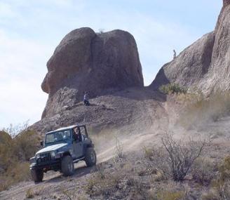
Dona Ana Trail (Easy to Moderate 1-3)
The Dona Ana Trail is located about 5 miles north of Las
Cruces. It's more of a "Large playground" than a trail,
consisting of several trails that loop around and
interconnect. Ranging in elevation from approximately
4,100 to 4,800 feet, the trail takes you in and around the
foothills of the Dona Ana Mountains. Much of the trail
consists of sandy arroyos, but there are several rather
steep hill climbs and descents, and a few scary
off-camber obstacles. Just a few miles to the west is the
Dona Ana Peak, which is about 5,700 feet in elevation.
This portion of the trail is just less than 10 miles long and
takes 4 to 6 hours to complete.
| Trails |


Eye of the Needle


The foothills are steep, and start off only about 50 ft high. With each new hill they get higher and taller
and the trails get steeper and steeper when you go up all you see out the windshield is sky. When you
come down (Everyone HATE’S going DOWN) all you see is the wash bottom in front of you, and
everything that is not bolted down in the back, ends up in the front seat with you! While this type of trail
does not look like it, it could be dangerous, not knowing how to climb or more correctly when to stop,
can have tragic results.
These foothills seem to be made of the same type of terrafirma as a lot of the foothills in the southwest,
that is, a mixture of sand and rock. These foothills seem to have a harder base than many of the
foothills OL’Skool has seen. There are a lot of trails in the area and OL’Skool has its own rout that we
take. OL’Skool recommends vehicles with VERY good ground clearance for the (Easy to Moderate)
trails. On this trail you will dip into V shaped obstacles that your rear bumper may drag as you pull out of
it and there are about 5 Moderate obstacles on the trail. The first obstacle that we stop at is a small hill
that we call the (Test Hill) it’s only about 50 ft high and full of ruts. For stock vehicles it’s a great hill to
test your vehicles capabilities, everyone does not have to climb the Test Hill, there is a bypass to the
left. On the next obstacle (Lions Mouth), as you wait for your turn to go over the edge and into the
abyss, the jeep in front of you goes between two rock outcroppings and head down. It’s so sharp a
drop off that all you can see is the bottom of the jeep as he goes over the edge and is gone! You get
the impression that you are waiting your turn to drive down into the throat of mother earth! The two
rocks look like giant teeth and the jeep in front of you barely fit. As you move up for your turn all you
see are the teeth and the sky. You thread your way between the teeth the front of the jeep drops and
finally out in front of you over the hood you see the bottom of the hill and beyond that more hills and
then the Dona Ana Mts. in the distance.
For the next 20 minutes we travel on the trail that takes you up and down the hills, this is an easy part of
the Dona Ana’s. Then we always stop at the same location on the trail where we all get out and hike for
about 20 minutes if their in good physical condition, but after this the trail has a moderate climb
(Ruts/Loose Rock) to the top of the trail. Some of the stock vehicles take three or even four tries before
making it to the top but they do make it.
After the hike/Ruts, the trail is on the (Easy) scale for the next 40 minutes and then you start to climb up
some very steep hills. The second hill stock vehicles are definitely challenged because of the loose
rock and the steepness of the hill. Stock Jeep Cherokees make it with street tires but not without tires
spinning and engines revving.
Next is a visit to what OL’Skool calls the Bat Caves, it’s a short hike up a hill into two small caves in the
mountain side. Then we climb the steepest hill on the trail, it is sold rock and about 200 ft high. Stock
vehicles have an easy time on this hill because it is sold rock but, it is very intimidating and it locks you
back into your seat and all you see is SKY!
There is one more (sold rock) hill climb after this and then the trail turns into a (Moderate Trail) where
stock vehicles may drag there rear bumpers if their ground clearance is low. There is also a ledge that’s
about 18 inches high that you must climb over in order to get off the trail and there is no bypass.
After the 18 inch ledge we come to “Eye of the Needle”. We park the vehicles at the bottom of the trail
except for the vehicles that can climb to the top of the trail to reach the Eye. In order for vehicles to
reach the Eye (Hard Trail) they need to have 33 inch tires and one locker. We normally hike (Steep Hike)
to the top of the top of the trail and take pictures around the Eye.
After the Eye we leave the trails and set up camp in the desert or people head back home. If we start the
trail at 10:30 we are normally done around 3:00 (15:00).
Caves
Eye


